Transportation
Please find a searchable version of the above Map of the University of Toronto Campus here. We took the map from the above site where you can enter the name of a building and the map will center on it - very convenient :)
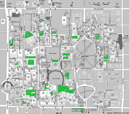
In this map you can see all the buildings on campus as well as the surrounding TTC subway stations. The Deparment of Physics is located in McLennan Physical Laboratories, 60 St. George Street.
The subway system in Toronto consists of basically two lines, the Bloor/Danforth line going east-west along Bloor and Danforth and the Spadina/Yonge subway line going north-south along the U-shaped route Yonge - Central Station - Spadina. There are street cars or buses running all over the city. For further information, please take a look at the section Getting to UofT from Downtown and around in Toronto and at the website of the Toronto Transit Comission (TTC).
PLEASE NOTE THAT DUE TO CONSTRUCTION, THE COLLEGE STREET STREETCAR DOES NOT RUN AT THE MOMENT!
Getting to UofT from the Airport
There are various ways to get to campus from the airport, in increasing order of expense (subway or taxi usually best):
- Subway: Take the 192 Airport Rocket (bus) to Kipling station. The bus runs every half an hour or so, less often off-peak, and you need exact change to pay ($2.25). It stops at all the terminals, but you may need to go up or down a floor from arrivals. See more information. From Kipling station, take the subway 15 stops to St. George (no need to pay again - the bus fare includes the subway transfer). Walk south on St. George St. about 0.7 km to 60 St. George. 60 St. George St. is a 15-story tower with small telescope domes on the roof, set back 100 m from St. George St. Takes about 50 minutes. If you have luggage and are coming to UOFT, you may wish to change to the Spadina street car at Spadina station, and get off at Willcocks. Walk east on Coxwell to Huron, turn south and enter the tower on the east side just before Russel Street, about a 3 minute walk.
- Airport bus: Take the express bus to "downtown hotels", which stops at a series of hotels in the city centre. Get off at the last stop, the Delta Chelsea Inn, which is about 1.3 km from UOFT, and take a taxi; or walk west one block to Bay St., north one block to College St., west 1 km to St. George St., and north one block to 60 St. George. Costs about $15, and takes one hour to UOFT.
- Taxi: Go outside the terminal to the taxi stand. The flat-rate fare to downtown will be $35-$40 plus tip. Tell the driver you want to go to 60 St. George St., which is one block north of College. There are two kinds of taxis: limos and taxis. The limo drivers wear a hat and cost $5 more. Takes about 1/2 hour. The standard tip is 15%.
Getting Downtown from the Airport
Basically one has the same options as when going to UofT, which is located about 2km from the intersection Bloor/Yonge and the core of downtown Toronto.
- Subway: Take the 192 Airport Rocket (bus) to Kipling station. The bus runs every half an hour or so, less often off-peak, and you need exact change to pay ($2.25). It stops at all the terminals, but you may need to go up or down a floor from arrivals. See more information. From Kipling station, take the subway downtown (no need to pay again - the bus fare includes the subway transfer) and get off at the appropriate stop. Please take a look at a map of the city of Toronto and at the website of the Toronto Transit Comission (TTC - the local public transport system), especially the route maps.
- Airport bus: Take the express bus to "downtown hotels", which stops at a series of hotels in the city centre. Please take a look at their website for details.
- Taxi: Go outside the terminal to the taxi stand. The flat-rate fare to downtown will be $35-$40 plus tip. There are two kinds of taxis: limos and taxis. The limo drivers wear a hat and cost $5 more. Takes about 1/2 hour. The standard tip is 15%.
Getting to UofT from Downtown and around in Toronto
Depending on your available funds, you can get around using the subway or taxis. The City of Toronto offers this great map of the Greater Toronto Area (GTA).
- Public Transit:
A single fare is CAD2.25 (no change given). It is advisable to buy tokens/ tickets available at subway stations in packets of 5 or 10 which cost CAD9.50 and CAD19.00 respectively. Another option is a day pass for CAD7.75 per day which can be used by a single adult from 9:30am to 5:30am the next morning on weekdays and by two adults from beginning of service to 5:30am next morning on Sundays. Finally there is the so-called Metropass which is available at a discounted rate from the Student Administrative Council and enables 1 month's use of the TTC system. Before buying, you might consider whether it is cheaper to go with tokens.
The subway service (PDF) is as follows:
- Weekday & Saturday service approximately 6:00am - 1:30am.
- Sunday service approximately 9:00am - 1:30am.
running about every 2-5 minutes.
The surface routes (PDF) have regular hours of operation starting at about 6:00am to about 1:00am, with Blue Night Service (PDF) running every 30 minutes or better from 1:30am to 5:00am.
PLEASE NOTE THAT DUE TO CONSTRUCTION, THE COLLEGE STREET STREETCAR DOES NOT RUN AT THE MOMENT!
- Taxis :
If you are in a hurry, you can call a taxi (Beck Taxi 416-449-6911, Co-op Cabs 416-504-2667, Black Diamond 416-366-6868) or a limousine from Aerofleet (416-449-4990), Aeroport (416-255-2211) or Emerald Taxi (416-590-9000).
Back