Reference:
Chun, K.-Y., and N. Vasiliev
Pn Source-Specific Station Corrections
for IMS Stations in Canada and East-Asia.
Geological Survey of Canada Open File Report #1800
(with CD attachments), 2004.
Development and application of regional Source-Specific Station Corrections (SSSCs) have been carried out for several seismic stations of the International Monitoring System (IMS) for the Comprehensive Nuclear Test Ban Treaty Organization (CTBTO). They have demonstrated that event locations can be improved significantly by applying travel time corrections relative to the default values of IASPEI-91 now in use at the International Data Center (IDC) of the CTBTO.
The current project is aimed at developing Pn SSSCs for 9 Canadian stations involved in the IMS operations. The National Data Center of Canada (CanNDC) serves as the principal source of data. We supplement the NDC data by adding data from International Seismological Centre (ISC) online bulletin and use some data collected during the prototype IMS operations.
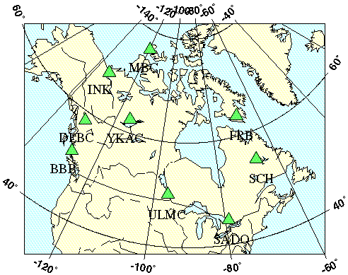
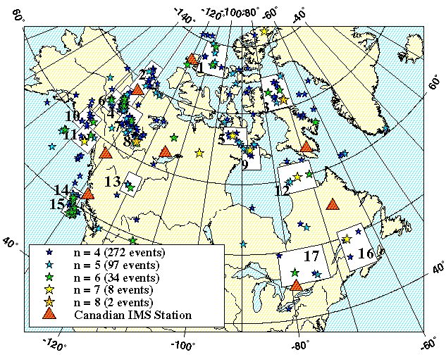
IMS Seismic Stations in Canada
In summary the project consists of three main steps:
There are a number of ways to develop SSSCs. The good source to study these methods and to understand pros and contra of each is the proceedings of annual Seismic Research Symposium devoted to Nuclear Explosion Monitoring.
For given case study we have decided to generate SSSCs through the transient tomographic Pn velocity model based on the head wave approximation. This choice is defined mostly by high volume of well-distributed data available due to the long history and high culture of seismic observations in Canada. We assume the crust features known for this region and use 2 models by Mooney et al. CRUST 5.1 and Laske et al. CRUST 2.0
As an initial step we make an inversion for the big tectonic regions with predefined borders, while the final model is produced in a more general way. The sizes of cells for tomography problem solution are estimated grounding on the data density and corresponds to the goal of the study.
From the whole data volume we select the part with well-located epicenters and origin time. Only event parameters estimations made by Canadian NDC using regional velocity models and close to epicenter observations are used to make the travel time error defined by epicenter location error as low as possible.
The final step is the SSSCs generation on the base of found tomographic model of the topmost mantle and corresponding crustal model. Accompanying modeling errors are inferred from the scatter of the observations around travel time plots built for the different tectonic provinces. These provinces are outlined on the base of the tomographic model and using general geophysical knowledge on geotectonic structure of Canada.
The validation test is performed using subset of the epicenters located by Canadian NDC to assess the effect of the efforts.
We have access to the Canada-related data via the two agencies: CanNDC and ISC . Whilst the data are in principle available from 1964 for ISC and even earlier for CanNDC, we limited ourselves with the period starting from 1980 to make certain the methodology of extracting the data (seismic sensors response, phase picking rules, event location algorithm etc. ) is consistent with its modern status. The general characteristics of the initial dataset are the next:
| Agency | Data Coverage | Total Number of Reported Events | Number of Events Reported Exclusively by the Agency | Number of Stations | Number of P Phases |
|---|---|---|---|---|---|
| CanNDC | Canada and vicinities | 43,412 | 30,856 | 2,042 | 345,773 |
| ISC | North America | 16,651 | 11,465 | 1,321 | 418,075 |
The data have been reformatted and put into the database. We tried to reserve the fields for any parameters
that seemed to be helpful for further selection. To see the main tables and their relationships go to
Details.
The data selection for further processing was made according to the next criteria:
After selection the number of available phases decreased by factor 6-7 for the both agencies. To see how selection affected the CanNDC data go to Details.
After the data were screened out we had the next information available:
| Agency | Number of Events | Number of Stations | Number of Pn Phases |
|---|---|---|---|
| CanNDC | 10,030 | 510 | 49,292 |
| ISC | 4,971 | 992 | 67,410 |
For CanNDC the majority of initial data was declined due to too few CanNDC stations defining an epicenter
(50% of all events) and too many very short distance observations (50% of all phases, usually Pg and Pn). The main reason for
rejecting a big deal of ISC data was that we took only ISC phases linked to CanNDC epicenters.
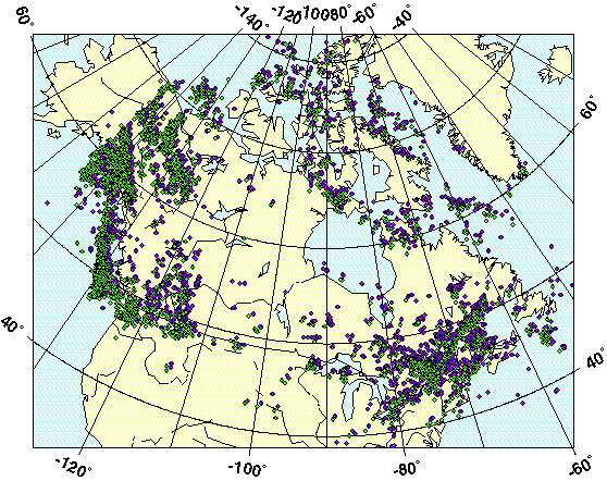
The event with related phase data to be processed at the next step are shown on the map below. To see the ray coverage maps and histograms of ray lengths distribution for each agency go to Details.
Events with Pn phase information: CanNDC (green + violet), ISC (green)
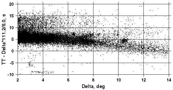
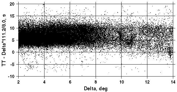
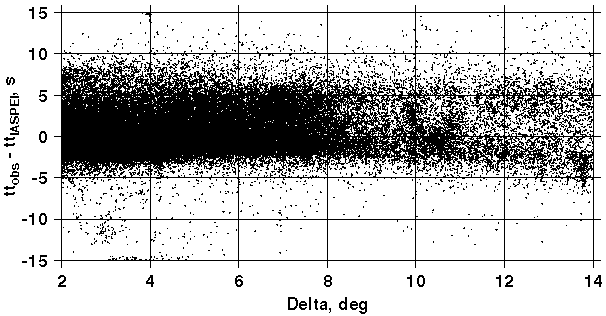
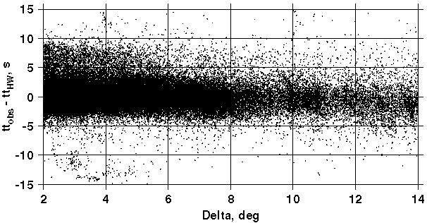
On the following two plots the reduced travel times against epicentral distance are shown for the both agencies. The
value of ISC data is clearly seen from these figures: improvement in ray geometry and data density enrichment for
far-regional distances have resulted in change of point distribution pattern. The provinces with Pn velocities
lower than 8.0 km/s contribute sufficiently more points for ISC plot. Therefore ISC data were expected to improve
the resolution for such provinces as Cordillera and Appalachians.
CanNDC Observed Travel Times
ISC Observed Travel Times
As the starting point we adopted simplified version of tectonic elements map of North America after LITHOPROBE project (Phase V Proposal, 1997, p.1-2). We have slightly changed the original map:
Simplified Tectonic Scheme of Canada
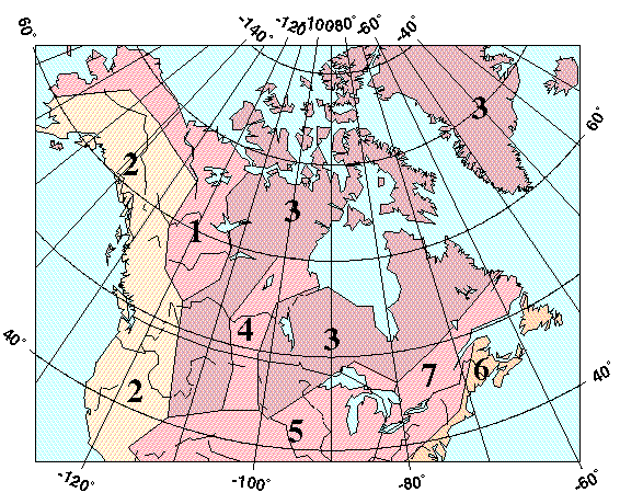
| Province | Pn Velocity [km/s] Inverted from Data: | |
|---|---|---|
| CanNDC | ISC | |
| 1. Taltson | 8.12 | 8.11 |
| 2. Cordillera | 8.02 | 7.90 |
| 3. Canadian Shield | 8.17 | 8.12 |
| 4. Trans-Hudson | 8.12 | 8.14 |
| 5. Interior Platform | 8.16 | 8.15 |
| 6. Appalachians | 8.16 | 8.02 |
| 7. Grenville | 8.12 | 8.10 |
These results suggest us to join CanNDC and ISC data for further processing.
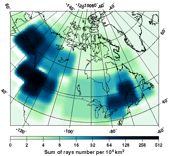
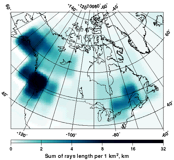
For further inversions we used the cells of smaller size instead of provinces with predefined borders. We divided the whole area of interest by 26 cells of 8°x16° (latitude x longitude) and 48 4°x8° cells. The way of partitioning was dictated by data density. The maps of two parameters: the number of rays per 10,000 km2 and the sum of ray lengths per 1 km2 are shown below.
Ray Density Map. The Number of Rays per 10,000 km2
Ray Length Map. The Sum of Rays Length [km] per 1 km2
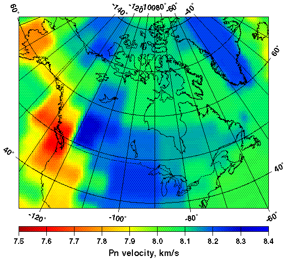
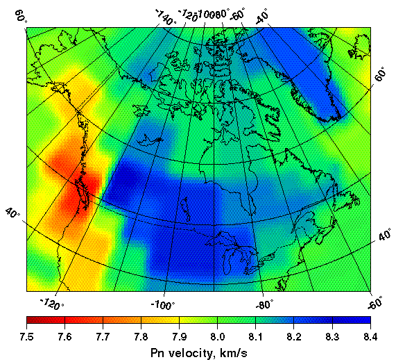
The resulted models are shown at the next three maps. To understand the influence of the crust velocity structure upon the results the inversion has been made for three cases of crust velocity models further referred at as M0, M1, M2: 1-D IASPEI-91, 2-D 5x5°Mooney, Laske and Masters model and 2-D 2x2°Laske, Masters and Reif model.
Pn Velocity Map for 1-D IASPEI-91 Crust Velocity Model (M0)
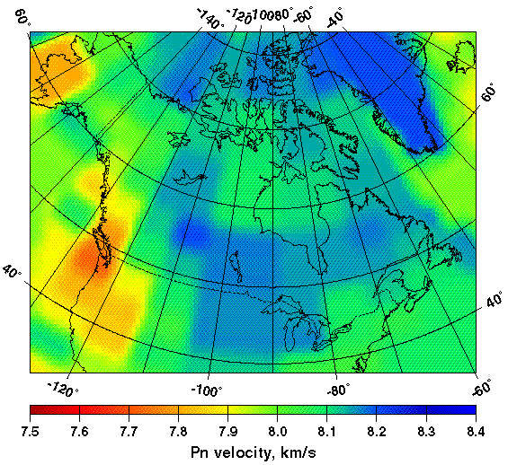
The results delivered by 2-D crustal models are obviously of wider Pn velocities scale. The most prominent differences,
as one could expect, occur for the transient ocean-continent zone where the crustal parameters change notably.
Note that the velocity features beyond our data coverage, for example Greenland, are defined by background model (RUM).
Pn Velocity Map for 2-D Mooney et al. Crust Velocity Model (M1)
Pn Velocity Map for 2-D Laske et al. Crust Velocity Model (M2)
The new Pn velocity model results in decreasing both bias and scatter of observed travel times from modeled ones comparing to the reference IASPEI-91 model. To understand why the scatter for first degrees of epicentral distances at the figures below seems not to differ drastically, one has to keep in mind that almost 75% of all travel time data fall into small region in South Cordillera. We think that our cell size here is too big to account for very fast changing Pn velocity features. On the other hand the prominent scatter decrease happens beyond 6° where the IASPEI-91 point pattern corresponding to different Pn velocities diverges to the single point cloud along the 0-line when the Head Wave Tomography Model comes to play.
Residuals Between Observed and Modeled Travel Times
IASPEI-91
CRUST 2.0 + Head Wave Tomographic Model of the Mantle (M2)
The scatter of model-generated travel time deviations from observations changes with epicentral distance in different ways for IASPEI-91 and Head Wave model: the latter model makes the scatter lower and more uniform for the whole distance diapason. To see the distance depending scatter and average values calculated along the distance go to Details.
At this step we directly plotted travel times for 5 areas (super provinces) containing provinces of similar Pn velocity features. The map is shown below; the regions borders are listed in the Table. To see the travel time for shown regions click on the corresponding area or go to Details.
Regions for Travel Time Plotting
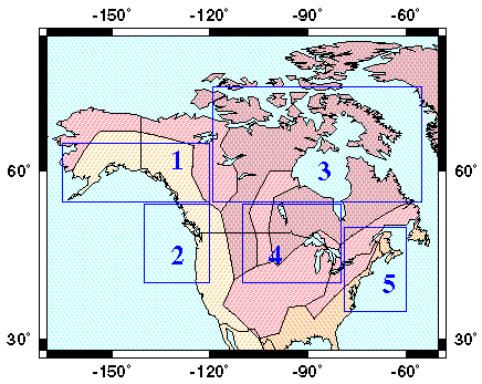
For each of these 5 super provinces we have calculated scatter and average in 1° windows. The next plot displays the travel times for all regions, to see observed travel times for each region go to Details. Dotted lines denote values for the IASPEI-91 and East European Platform.
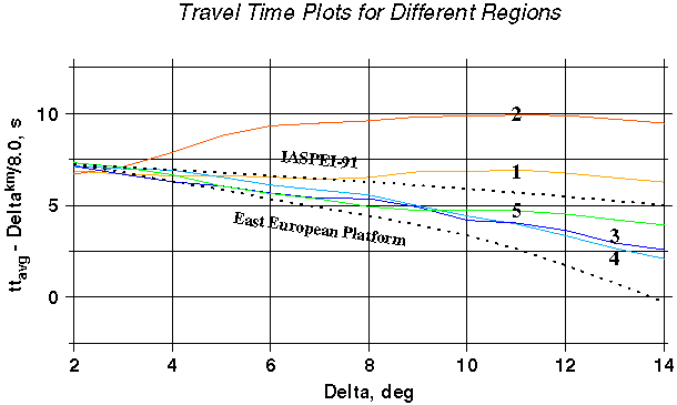
The scatter correlates well with Pn velocity: the higher the velocity is, the lower is the scatter. This fact suggested us to join data related to super provinces 1,2 and 3,4 into two groups and to repeat rms calculations. Resulted generalized distance-dependent scatter plots for "fast" and "slow" tectonic provinces are shown below. To see the particular plots evolution into the final one, go to Details.
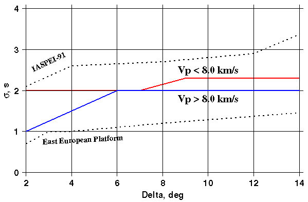
Generalized Distance Dependent Modeling Errors for 2 Types of Tectonic Provinces
The final product (SSSCs and corresponding modeling errors) is to satisfy technical requirements listed in [Nagy, 1996]: the corrections and errors are to be specified in the nodes of rectangular grid; at the boundaries they must have smooth transition to the background model. To meet these requirements SSSCs and modeling errors were generated along the rays around each IMS station at the nodes of circular grid, resampled to rectangular grid, and smoothed to the background (IASPEI-91) values at the edges with bi-cubic spline interpolation.
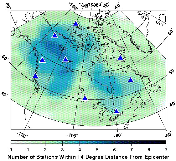
Before further discussion of the SSSCs we would like to demonstrate important differences in corrections' coverage that arise from the scale of the tomography model developed. The next maps reflect the number of Canadian IMS stations within some distance from every point of the map. The maps for distances 14° and 20° radius around Canadian IMS stations are shown here.
IMS Stations Location Coverage for 14-degrees Radius Around the Stations
IMS Stations Location Coverage for 20-degrees Radius Around the Stations
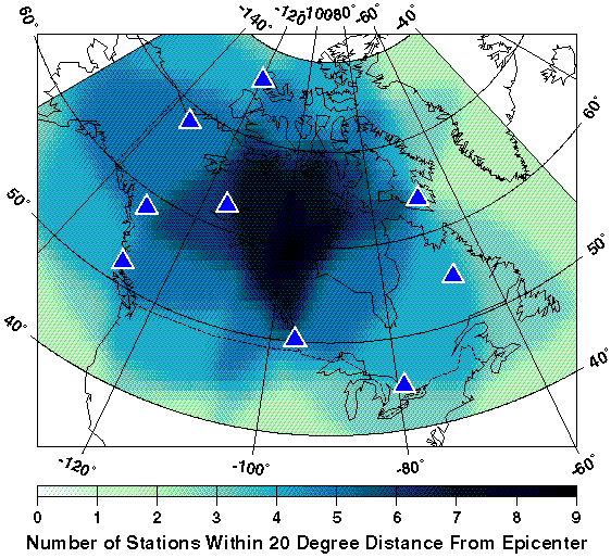
The maps above show that when the model-based SSSCs are defined up to 14°, central Canada has poorer coverage than regions to its east and to its west. If the SSSCs could be defined to 20°, the best coverage would be found in central Canada. The average number of stations that are situated within 14° from any given point is around 2.2. This increases to 3.9 when the maximum distance is lengthened to 20°.
As our models were developed for distances up to 14 degrees we have chosen this radius to produce SSSCs and errors. Finally SSSCs and modeling errors were tapered to the IASPEI values at 20 degrees by b-cubic spline interpolation. By dumping modeling errors we try to handle the problem of high uncertainties in 14°-20° transition interval.
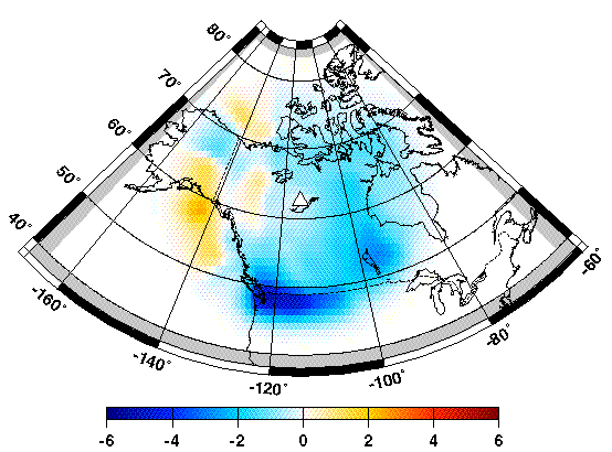
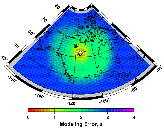
The example of SSSCs along with corresponding modeling error surface for IMS station YKAC (depth = 0) is shown below. Here we display the corrections generated from the mantle velocity model tied with Laskey crustal model. To see the differences between SSSCs generated using mantle models coupling with different crustal models as well as the differences between modeled and observed travel time deviations go to Details.
SSSCs for YKAC (depth = 0, Model M2)
Modeling error for YKAC (depth = 0, Model M2)
Here we put the final product of the Project: Pn Source-Specific Station Corrections and their modeling errors for all 9 Canadian seismic
stations. The SSSCs come in two flavors:
The next links take the user to the SSSCs and modeling errors in two different forms: maps and IDC-compliant tables. The crust velocity
model used is denoted here as corresponding suffix: "iaspei" for model M0 and "laske" for model M2.
The direct way to validate the SSSCs is to compare the solutions for the events with known coordinates after locating them with and without the SSSCs. For given case study we faced the real problem in this way. Center for Monitoring Research (CMR) has provided us with Ground Truth (GT) events collected for Canadian territoty. Among these GT events we did not find any of 5 km and better accuracy that were detected by enough number of Canadian IMS stations to be located. The mining and rockburst events appeared to be of too low magnitude to be recorded by 4 and more IMS stations. The ground truth events candidates we have from GSC were rejected on the same basis.
We tried to find some GT5 events among all GSC data using recently developed criteria listed in [Bondar et al, 2002]. According to this source the next requirements to the defining network provide 5 km accuracy of the epicenter:
| epicentral distance: | 2.5° | |
|---|---|---|
| number of stations: | 10 and more | |
| azimuthal gap: | < 110° | |
| secondary azimuthal gap: | < 160° | |
| distance to closest station: | < 30 km |
Grounding on these criteria we have found 892 such events out of 43,412 altogether. Only 5 of them have appeared to meet the requirements to be recorded by 2 and more Canadian IMS stations within regional distance and by 4 and more Canadian and USA IMS stations that is necessary minimum for location. All these events took place at the same area on the western end of Canada-USA border. We relocated these events by two different ways:
Event locations, station distribution and the relocation results are shown on the map and plot below.
IMS Stations Coverage for 5 GT5 Events
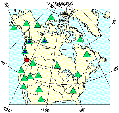
Green triangles denote the IMS stations, blue triangles are the IMS stations and their surrogates used for relocations, SSSCs were applied for only 3 nearest Canadian stations: BBB, DLBC, and YKAC. Epicenters are shown as the red stars.
On the location plot below IASPEI-91 solutions, SSSC-M2 solutions and their 90% error ellipses are shown. The plot is scaled in km relatively the centers of events, the size of the star denoting Ground Truth approximately corresponds to its accuracy, i.e. 5 km.
Relocation Results for 5 GT5 Events
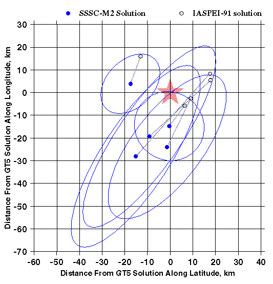
While the station geometry around these epicenters was not the worst case, the stations with corrections provide only small part of all readings. However, they moved epicenters from 15 to 50 km away of their IASPEI locations. In fact application of corrections did not improve the solution, but we would address this problem to one-side coverage by stations with SSSCs. 4 of 5 GT5 events have fallen into the error ellipses.
From this point we looked for another way to evaluate the corrections. For this reason we have selected epicenters from which 4 and more Pn/P arrivals were recorded by Canadian IMS stations and their surrogates. We did not attempt to estimate the real accuracy of these epicenters conditionally accepting them as GT20 events given they were located by Canadian local/near regional network using local velocity models. We have found 413 such events with 1849 phases (1505 Pn and 344 P). The average number of regional Pn readings does not depend upon the number of stations per event and varies from 3 to 4 from one event to another. The epicenters distribution for these 413 events is shown on the map below.
Events Recorded by 4 and more Canadian IMS stations
For these events the relocation study has been performed to see how the corrections work. To see maps comparing
solutions using IASPEI-91 and SSSC-M2 model choose the number of region indicated on the map above:
We understand that this is not pure validation test as the solution in given case of the very small number of defining stations essentially is the result of trade-offs between at least the next 3 factors:
We have tried to mitigate the effect of 2 first factors by restricting the station geometry. Therefore we further analyze only the location results for events that are favorably situated relatively IMS stations. The next two cases are assumed:
The next two plots display the relocation results in terms of mislocation between solution and CanGSC event coordinates for SSSC-M2 vs. IASPEI-91. The bias of point from the 45° line towards one of the 2 axes indicates the better location using model corresponding to this given axis.
SSSC-M2 vs. IASPEI-91 Mislocation for Events in Northwestern Canada
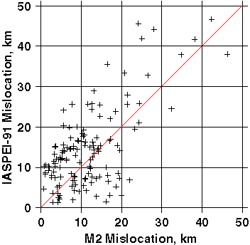
SSSC-M2 vs. IASPEI-91 Mislocation for All Events with Gap < 225°
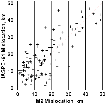
The both plots clearly indicate better location using SSSCs. When analyzing the plots for mislocations less than 20 km one has to keep in mind the accuracy of Can NDC solutions (conditionally accepted GT20 for Western Canada and Southern Quebec where GSC has regional networks and somewhat worse accuracy for the other territories). In this light the points which have bigger SSSC-M2 mislocation than that for IASPEI solution forIASPEI-91 mislocation less than 20 km do not necessary mean location deterioration. Note that for this region the plots have only very few (2 and 3) points with SSSC-M2 mislocation exceeded 20 km. Below some validation metrics are listed for all-Canada events with the gap restriction:
| Dataset Characteristics | ||
|---|---|---|
| number of solutions: | 153 | |
| average number of Pn/P phases per event | 4.5 | |
| average number of Pn phases per event | 3.6 | |
| average number of Pn phases within 14°per event | 3.0 | |
| Validation Results | ||
| percentage of events moved closer to GT20: | 62% | |
| average improvement: | 8 km | |
| median improvement: | 7 km | |
| percentage of events moved away from GT20: | 38% | |
| average deterioration: | 5 km | |
| median deterioration: | 4 km | |
| average 90% ellipse area for IASPEI-91: | 5762 km2 | |
| average 90% ellipse area for SSSC-M2: | 3260 km2 | |
| median 90% ellipse area for IASPEI-91: | 4760 km2 | |
| median 90% ellipse area for SSSC-M2: | 2750 km2 | |
| percentage of GT20 events covered by 90% error ellipse for IASPEI-91: | 91% | |
| percentage of GT20 events covered by 90% error ellipse for SSSC-M2: | 87% | |
| average origin time error for IASPEI-91: | -0.77 ± 0.22 sec | |
| average origin time error for SSSC-M2: | -0.50 ± 0.21 sec | |
The results show that SSSCs indeed improve the locations, decrease ellipse error area not deteriorating significantly its confidence level; improve estimation of the origin time that may reflect better depth estimation potentiality.
The main intent of this study has been to use the Canadian regional seismological observations by dense national network to improve the seismic event location performed by very limited number of stations operated as a part of the International Monitoring System (IMS). For this purpose we use seismic phase Pn which is of principal importance in a problem of event location in regional zone. We have inverted Pn regional travel times to produce the Pn velocity tomography model for the whole Canadian territory and then we inverted the velocity model back into the time domain producing the modeled travel time surface around each seismic station. By subtracting the standard travel-time values from values predicted by our model we have produced Source-Specific Station Corrections (SSSCs).
Both the Pn tomography model and modeled travel times correlate well with the tectonic features across Canada from Western orogenic provinces to the stable Canadian Shield to the East. We deterministically removed a significant part of the observed Pn station travel time scatter in regional zone by taking into account P velocity features of the most recent model of crust and newly developed model of uppermost mantle. After estimating the scatter for different geotectonic provinces this creates ground for estimating the more realistic error ellipse area around the epicenter solution.
In validation study we present evidence showing that application of newly developed travel-time corrections leads to improvement in epicenter location.
Last updated: 5 March, 2003
© 2003 Nikolai Vasiliev & Kin-Yip Chun