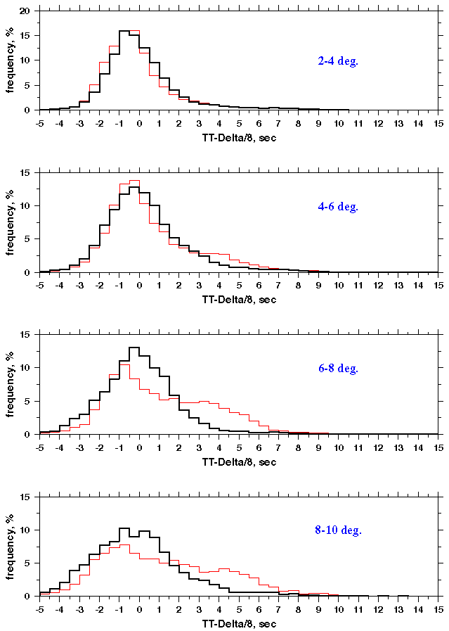
The table below lists the average (avg) and residual mean square (rms) for deviations of IASPEI-91 and Head Wave Tomography (Laske crust) model-generated travel times from observed values; the data are obtained for 1.2°-wide sliding window with a 1°-step.
| Distance, deg | 2 | 3 | 4 | 5 | 6 | 7 | 8 | 9 | 10 | 11 | 12 | 13 | 14 | |
|---|---|---|---|---|---|---|---|---|---|---|---|---|---|---|
| IASPEI-91 | avg, s | 0.15 | 0.12 | -0.15 | -0.73 | -0.89 | -1.16 | -1.20 | -1.15 | -1.02 | -0.62 | -1.02 | -1.23 | -0.21 |
| rms, s | 1.90 | 2.06 | 2.31 | 2.42 | 2.52 | 2.71 | 2.81 | 3.18 | 3.18 | 3.34 | 3.80 | 4.05 | 4.32 | |
| Head Wave (M2) | avg, s | 0.12 | 0.19 | 0.01 | -0.32 | -0.24 | 0.05 | 0.13 | -0.07 | -0.24 | 0.16 | 0.33 | 0.79 | 0.96 |
| rms, s | 2.04 | 2.14 | 2.29 | 2.20 | 2.11 | 2.08 | 2.24 | 2.58 | 2.60 | 2.72 | 2.82 | 3.02 | 3.07 | |
| Number of Observations | 16938 | 25534 | 16088 | 12003 | 8789 | 7539 | 4214 | 2126 | 2170 | 1743 | 1371 | 1340 | 759 | |
The histograms of residual distributions for these two models for distances up to 10° are shown below (IASPEI-91 - red, M2 - black).
| Region Number | Latitude | Longitude | ||
|---|---|---|---|---|
| Min | Max | Min | Max | |
| 1 | 55N | 65N | 165W | 120W |
| 2 | 40N | 55N | 140W | 120W |
| 3 | 55N | 75N | 120W | 55W |
| 4 | 40N | 55N | 110W | 80W |
| 5 | 35N | 50N | 80W | 60W |
Travel times reduced by 8.0 km/s are shown at the next plots. The lines denote Pn velocities from 7.8 km/s to 8.2 km/s with 0.1 km/s step. The line color corresponds to the color scheme accepted for Pn tomography study.
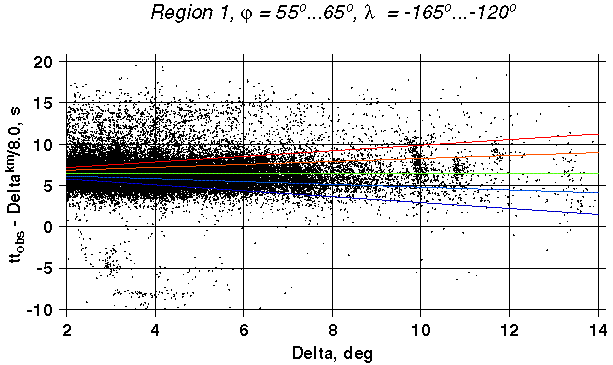
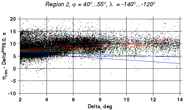
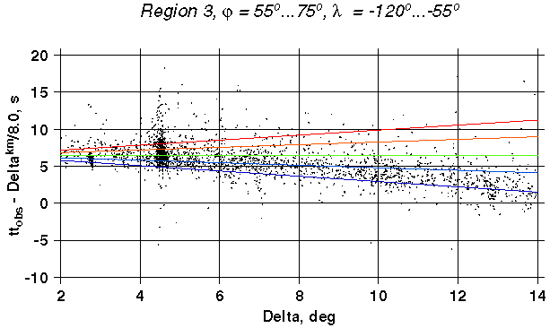
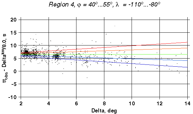
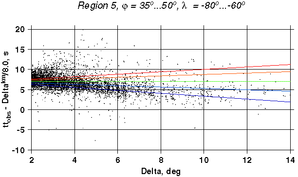
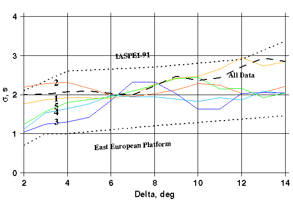
The scatter plot for 5 regions of different tectonic structure are shown below. Dashed line here displays rms resulted from the best fit Head Wave model (Laske crust) and all data. Dotted lines denote modeling errors for the IASPEI-91 and East European Platform.
Distance Dependent Travel Time Scatter (rms) for Different Tectonic Provinces
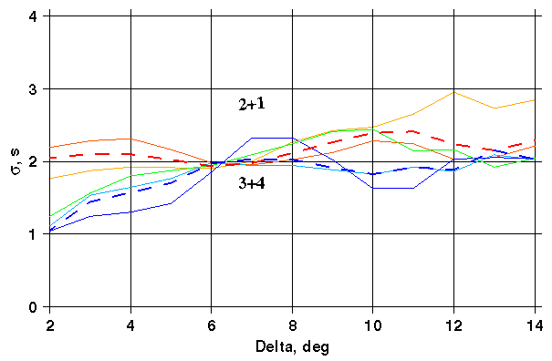
To make the data for the sigma estimation in narrow 1°-wide window more sufficient we repeated calculations joining observations from low Pn velocity regions 1,2 and high Pn velocity regions 3,4. The results are displayed below.
Distance Dependent Travel Time Scatter (rms) for Cordillera (1+2) and Canadian Shield (3+4)
Finally eyeball generalization has been made. For further studies we use two types of distance-dependant errors. Lower error is characteristic of the mantle with Pn velocity higher than 8.0 km/s, higher errors take place when Pn velocity is below 8.0 km/s.
Travel Time Scatter (rms) Generalization for 2 Main Types of Tectonic Provinces
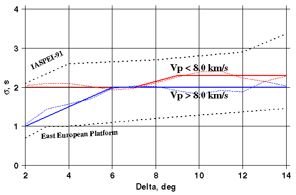
Note: we assume the value as modelling error keeping in mind that this in fact includes the modeling error itself, time picking error and error resulted from event solution uncertainties (hypocenter, depth, origin time).
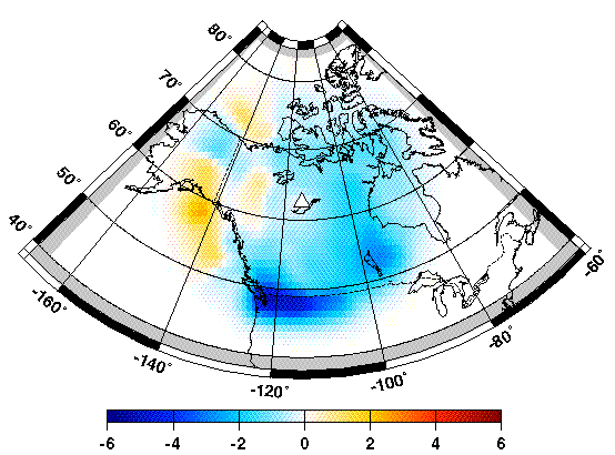
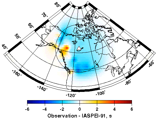
Here we display surfaces for zero-depth event built on observed Pn travel time residuals from IASPEI-91 tabulated values, and correction surfaces generated on the base of 3 pairs (mantle + crust) models. All results are obtained for station YKAC:
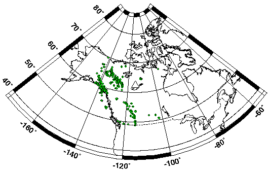
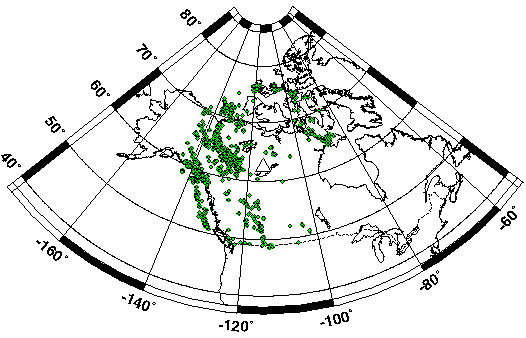
Distribution of 613 Events Used for Map Below
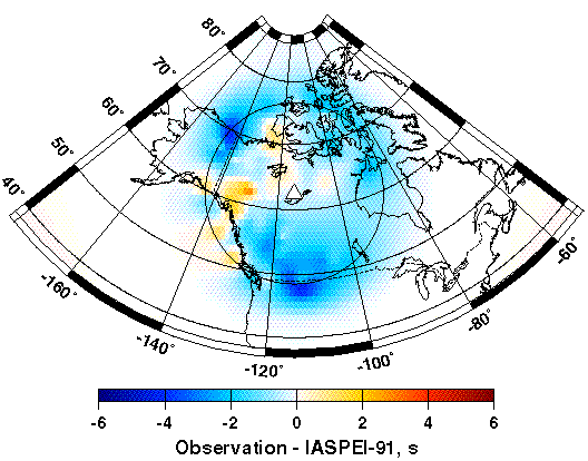
Observed Travel Time Residuals from IASPEI-91 at YKA for events with depth (0–10 km)
To increase the number of observations we selected 2443 events with depth within 0–40 km and accuracy not worse than 10 km and corrected travel times for the depth. The resulted maps are shown below.
Distribution of 2443 Events Used for Map Below
Observed Travel Time Residuals from IASPEI-91 at YKA for events with depth (0–40 km)
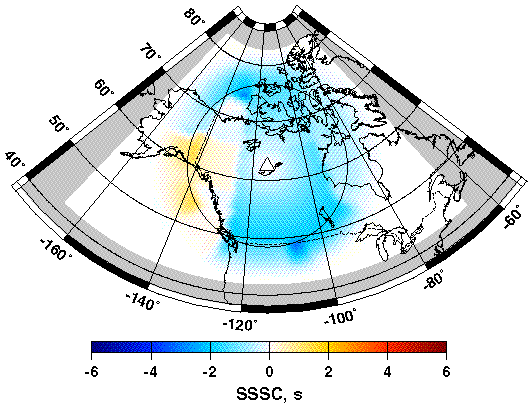
Below we show three types of SSSC surfaces generated for zero-depth events around YKA
SSSC-M0 (IASPEI-91 crust) for YKAC (depth = 0)
SSSC-M1 (Mooney crust) for YKAC (depth = 0)
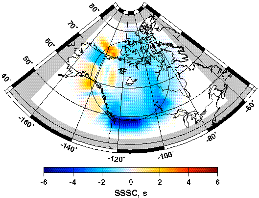
SSSC-M2 (Laske crust) for YKAC (depth = 0)