A spacecraft equipped with Canadian technology has begun its mission to answer one of the most basic but challenging questions in climate science: where is all the water?
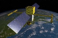
The Surface Water and Ocean Topography mission, or SWOT, was launched from California’s Vandenberg Space Force Base early Friday morning aboard a SpaceX Falcon 9 rocket. The low-Earth-orbit satellite was developed by NASA in partnership with the French space agency, CNES, with additional involvement from Britain and Canada.
SWOT’s aim is to measure the water levels of rivers, lakes and coastal waters of about 90 per cent of the globe and track how they change over time.
While the task may sound straightforward, the results promise to unlock a bounty of information about the water cycle, its relationship to climate and the consequences for people around the world.
Indeed, so important is the data that the scientists behind the mission describe it in the same terms that astronomers have used when talking about the James Webb Space Telescope.
“We’re speaking about a revolution in hydrology,” said Selma Cherchali, the head of Earth observation at CNES, at a prelaunch science briefing.
For decades, researchers have been able to rely on satellite imagery to measure the length and breadth of the countless bodies of water that dot Earth’s surface and to map the coastlines of every continent, but capturing water levels is an entirely different matter. Visually, there is no easy way to do this from space. Instead, gauges that measure water levels must be installed wherever such data is needed. However, that can only provide measurements at one point, and the global distribution of gauges is highly uneven, leaving many parts of the world underrepresented in the data.
Without water level data, estimating the total volume becomes guesswork – which in turn makes it difficult to answer a host of questions about drought, flood risk and water availability in many locations.
“Having these areas where there’s a dearth of information is horrible to deal with because you’re just left having to make assumptions,” said Thomas Piekutowski, the program manager for Sun-Earth system sciences at the Canadian Space Agency.
SWOT has been designed to bridge this knowledge gap by using a pair of antennae 10 metres apart that simultaneously fire radar pulses toward Earth’s surface thousands of times per second. The pulses are reflected by water and travel back up to the spacecraft. The slight difference in the time it takes the reflected pulses to reach each antenna separately allows the satellite to extract three-dimensional information about water levels to an accuracy of within 10 centimetres.
Read the full article in the Globe and Mail here:
https://www.theglobeandmail.com/canada/article-nasa-spacex-space-exploration-technologies-surface-water/#:~:text=In%20October%2C%20the,follow%20in%202031.